|
Welcome,
Guest
|
TOPIC: Houston's thread for hurricanes?
Re:Houston's thread for hurricanes? 15 years 8 months ago #14733
|
|
Please Log in or Create an account to join the conversation. |

Re:Houston's thread for hurricanes? 15 years 8 months ago #14764
|
Please Log in or Create an account to join the conversation. |


Re:Houston's thread for hurricanes? 15 years 8 months ago #14771
|
Please Log in or Create an account to join the conversation. |

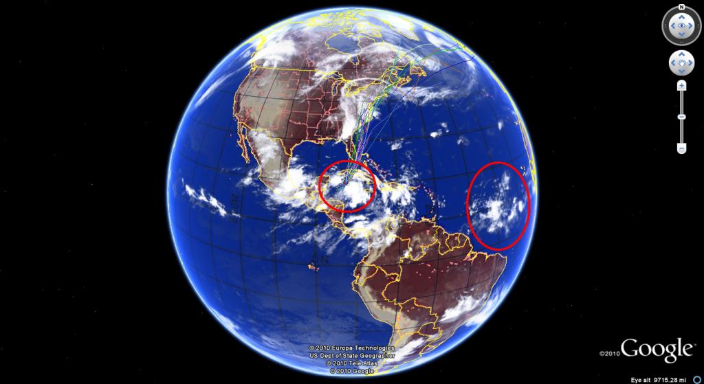
Re:Houston's thread for hurricanes? 15 years 8 months ago #14801
|
|
Please Log in or Create an account to join the conversation. |
Re:Houston's thread for hurricanes? 15 years 8 months ago #14802
|
|
Please Log in or Create an account to join the conversation. |
Re:Houston's thread for hurricanes? 15 years 8 months ago #14871
|
Please Log in or Create an account to join the conversation. |
Re:Houston's thread for hurricanes? 15 years 8 months ago #14956
|
Please Log in or Create an account to join the conversation. |
Re:Houston's thread for hurricanes? 15 years 8 months ago #14998
|
Please Log in or Create an account to join the conversation. |


Re:Houston's thread for hurricanes? 15 years 8 months ago #15044
|
Please Log in or Create an account to join the conversation. |

Re:Houston's thread for hurricanes? 15 years 8 months ago #15071
|
Please Log in or Create an account to join the conversation. |

Re:Houston's thread for hurricanes? 15 years 8 months ago #15202
|
Please Log in or Create an account to join the conversation. |

Re:Houston's thread for hurricanes? 15 years 8 months ago #15228
|
Please Log in or Create an account to join the conversation. |

Re:Houston's thread for hurricanes? 15 years 8 months ago #15230
|
|
Please Log in or Create an account to join the conversation. |
Re:Houston's thread for hurricanes? 15 years 8 months ago #15240
|
|
Please Log in or Create an account to join the conversation.
\"too soon old,too late smart\" my pap
Twenty years from now you will be more disappointed by the things that you didn’t do than by the ones you did do. So throw off the bowlines. Sail away from the safe harbor. Catch the trade winds in your sails. Explore. Dream. Discover.“ ---Mark Twain |

Re:Houston's thread for hurricanes? 15 years 8 months ago #15276
|
Please Log in or Create an account to join the conversation. |


Re:Houston's thread for hurricanes? 15 years 8 months ago #15299
|
Please Log in or Create an account to join the conversation. |

Re:Houston's thread for hurricanes? 15 years 8 months ago #15313
|
Please Log in or Create an account to join the conversation. |
Re:Houston's thread for hurricanes? 15 years 8 months ago #15478
|
Please Log in or Create an account to join the conversation. |

Re:Houston's thread for hurricanes? 15 years 8 months ago #15631
|
Please Log in or Create an account to join the conversation. |
Re:Houston's thread for hurricanes? 15 years 8 months ago #15752
|
|
Please Log in or Create an account to join the conversation. |
Re:Houston's thread for hurricanes? 15 years 8 months ago #15774
|
Please Log in or Create an account to join the conversation. |


Re:Houston's thread for hurricanes? 15 years 8 months ago #15777
|
|
Please Log in or Create an account to join the conversation. |
Re:Houston's thread for hurricanes? 15 years 8 months ago #15788
|
Please Log in or Create an account to join the conversation. |
Re:Houston's thread for hurricanes? 15 years 8 months ago #15902
|
Please Log in or Create an account to join the conversation. |

Re:Houston's thread for hurricanes? 15 years 8 months ago #15931
|
Please Log in or Create an account to join the conversation. |

Re:Houston's thread for hurricanes? 15 years 8 months ago #15958
|
Please Log in or Create an account to join the conversation. |

Re:Houston's thread for hurricanes? 15 years 8 months ago #16111
|
Please Log in or Create an account to join the conversation. |


Re:Houston's thread for hurricanes? 15 years 8 months ago #16173
|
Please Log in or Create an account to join the conversation. |


Re:Houston's thread for hurricanes? 15 years 8 months ago #16202
|
Please Log in or Create an account to join the conversation. |


Re:Houston's thread for hurricanes? 15 years 8 months ago #16329
|
Please Log in or Create an account to join the conversation. |


Re:Houston's thread for hurricanes? 15 years 8 months ago #16417
|
Please Log in or Create an account to join the conversation. |

Re:Houston's thread for hurricanes? 15 years 8 months ago #16640
|
Please Log in or Create an account to join the conversation. |

Re:Houston's thread for hurricanes? 15 years 8 months ago #16709
|
Please Log in or Create an account to join the conversation. |


Re:Houston's thread for hurricanes? 15 years 7 months ago #17451
|
Please Log in or Create an account to join the conversation. |


Re:Houston's thread for hurricanes? 15 years 7 months ago #17747
|
Please Log in or Create an account to join the conversation. |
Re:Houston's thread for hurricanes? 15 years 7 months ago #17767
|
Please Log in or Create an account to join the conversation. |
Re:Houston's thread for hurricanes? 15 years 7 months ago #18083
|
Please Log in or Create an account to join the conversation. |


Re:Houston's thread for hurricanes? 15 years 7 months ago #18175
|
Please Log in or Create an account to join the conversation. |
Re:Houston's thread for hurricanes? 15 years 7 months ago #18578
|
Please Log in or Create an account to join the conversation. |
Re:Houston's thread for hurricanes? 15 years 7 months ago #18580
|
|
Please Log in or Create an account to join the conversation. |
Donate
Please consider supporting our efforts.
Glassified Ads
1965 Glasspar Avalon |

1959 RedFish( / Boats)


Glasspar Tacoma( / Boats)


FG Login

FiberGoogle
Who's Online
We have 6883 guests and one member online